Alarming satellite pics show no clouds over India
Rainfall between 4 and 15 June fell 64% short of normal, with only 19.2 mm recorded against 53.7 mm.
Salar News
-
The delay has raised concerns for kharif crops such as paddy, soybean, cotton & pulses, as June is crucial for sowing (IMD)
New Delhi, 17 June
India's
southwest monsoon has shown worrying signs of stagnation, with satellite images
revealing vast cloud-free stretches over central and western India as the
national rainfall deficit widened to 40 per cent, according to the India
Meteorological Department (IMD).
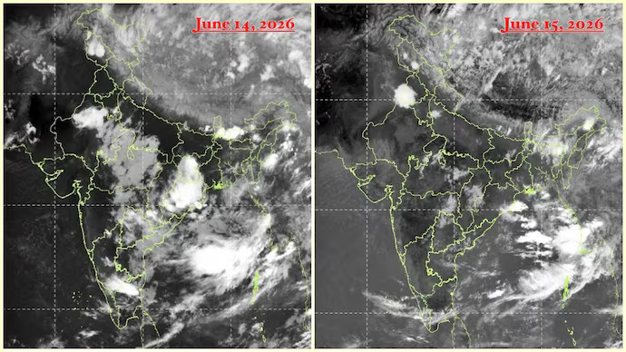
An
INSAT-3DS image captured on 15 June showed large parts of Maharashtra, Gujarat,
Madhya Pradesh, Rajasthan and interior Karnataka largely devoid of cloud cover,
signalling a weakening of monsoon activity over the country's key agricultural
belt.
Rainfall between 4 June and 15 June plunged 64 per cent below normal, with the country
receiving just 19.2 mm against the usual 53.7 mm. The deficit moderated to 40
per cent by 17 June, with cumulative rainfall at 39.7 mm compared with a normal
of 65.9 mm.
Maharashtra
recorded a 79 per cent rainfall deficit, Gujarat 98 per cent, Jharkhand 66 per
cent, Chhattisgarh 65 per cent and Meghalaya 85 per cent. Karnataka, Telangana,
Odisha, Bihar and Assam also reported deficient rainfall.
Weather
experts attributed the slowdown to weak moisture flow from the Arabian Sea and
unfavourable upper-level winds suppressing rain-bearing systems over central
and western India. Most organised convection remains confined to the Bay of
Bengal, Northeast India and parts of the equatorial Indian Ocean.
The delay
has raised concerns for kharif crops such as paddy, soybean, cotton and pulses,
as June is crucial for sowing.
Agriculture Secretary Atish Chandra said the government was awaiting the IMD's forecast on the likely onset of El Nino by the end of June before deciding on measures to mitigate any impact on the kharif season.
Share Now
Leave a Reply
Your email address will not be published. Required fields are marked *
Other Stories
.png)

.png)
.png)